
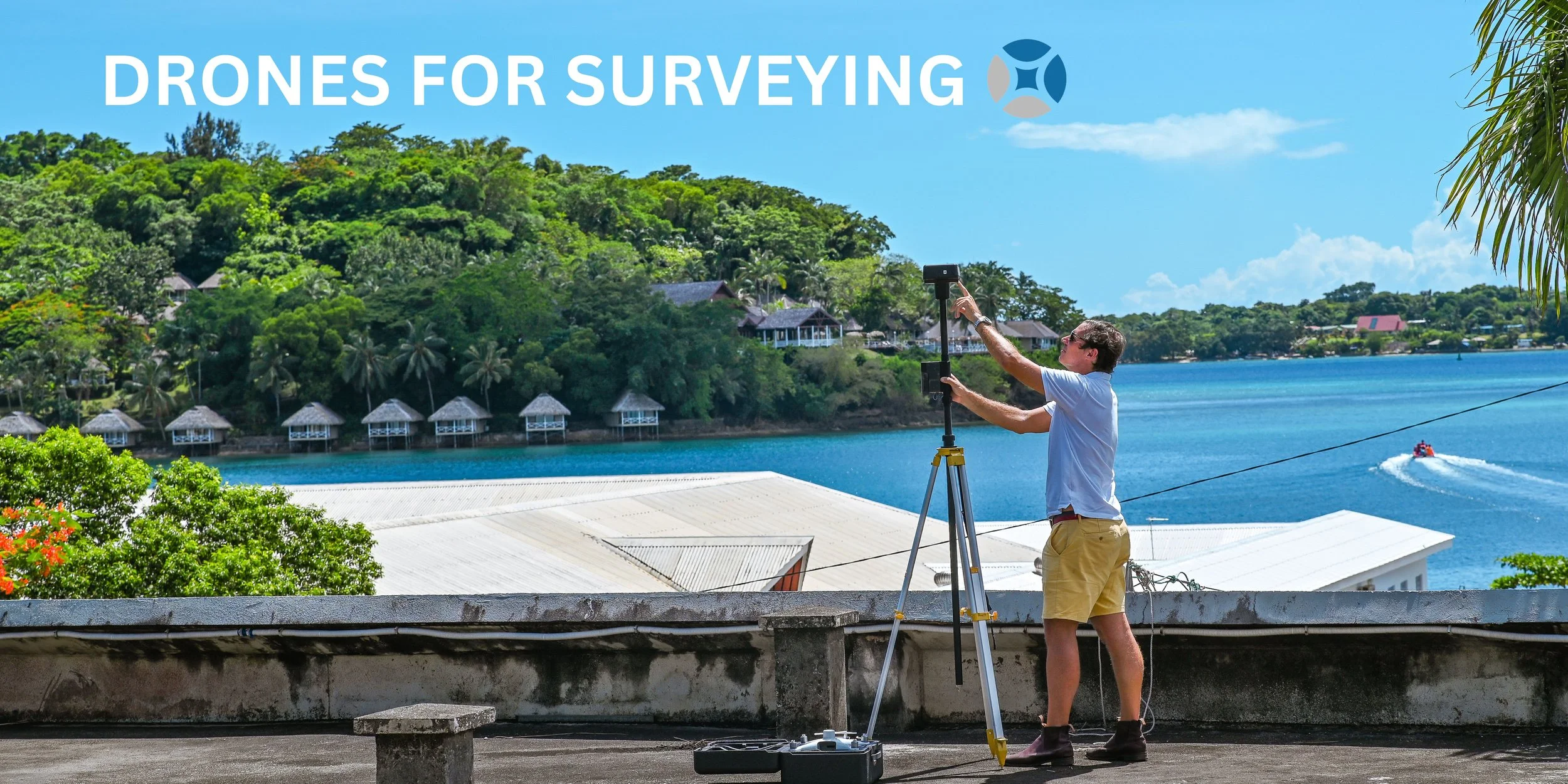
Revolutionising the Surveying Industry
Embracing drone technology for greater accuracy and efficiency
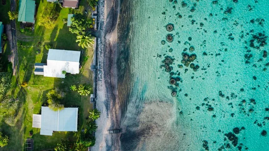
Drones equipped with high resolution cameras can capture detailed imagery from the air with excellent accuracy for a range of your needs including project planning, site mapping, volume calculations, progress-tracking, inspection, and more.
For more information on how we can help with your project, contact our Measure. By Drone team.
Our Products
Aerial Mapping
Measure By Drone are professionals in the capture and preparation of UAV and helicopter-based aerial mapping data. Their experience includes mapping a wide variety of landscapes and physical structures, offering experience and utilising fast, cost-effective data capture technology.
LIDAR
Airborne laser scanning offers the ability to map the ground hidden by vegetation, whether it be forest, scrub or long grass. Laser pulses find gaps through to the ground and returns accurate data for the creation of digital terrain models and contours.
Measure By Drone has access to the industry leaders in the South Pacific: RECON.
No project is too large. Make contact to know how our network can solve your LIDAR mapping needs.
Subdivision Design Services
Save time and resources. Design the subdivision before sending in the ground surveyors and the bulldozers.
Drone surveying allows a full understanding of the underlying land. Smarter design allows for better communities.
Drones to Enable AI Assisted Mapping for Building Footprint Measurements
& for Mass Valuation Models
The local council valuation role is out of date. With no accurate records of the number of buildings, identification of the building use, collecting rates for basic services is unobtainable. Efforts through aid funded program to value all of the properties failed.
Land Logic innovation, entrepreneurial thinking will utilise drone technology, AI, mass valuation models to provide an un-objectable valuation role.
'Challenging the rateable valuations has always been a problem in the past. Providing a valuation that can not be objected is key for the council. To reduce the costs to provide an updated valuation role will allow the rates to be reduced for lower income households while still significantly increasing the income for the council" Jeremy Dick Director.
Aerial Building Condition Assessments
Using controlled autonomous flight Measure By Drone pilots provide a high quality capture that can produce an exportable 2D or 3D model of the entire property or structure. Images don't lie.
For assessing a current building for assessment for repairs and maintenance, or an accurate assessment for property insurance. Have available an unobjectable record that is location and time stamped of your asset.
Records can be sored for cloud base for future reference in time of need. Cloud based means accessed anywhere. Quicker access to information for insurance claims.

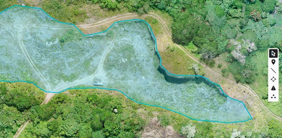
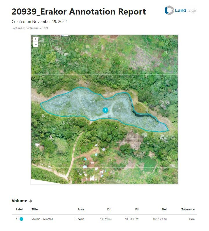
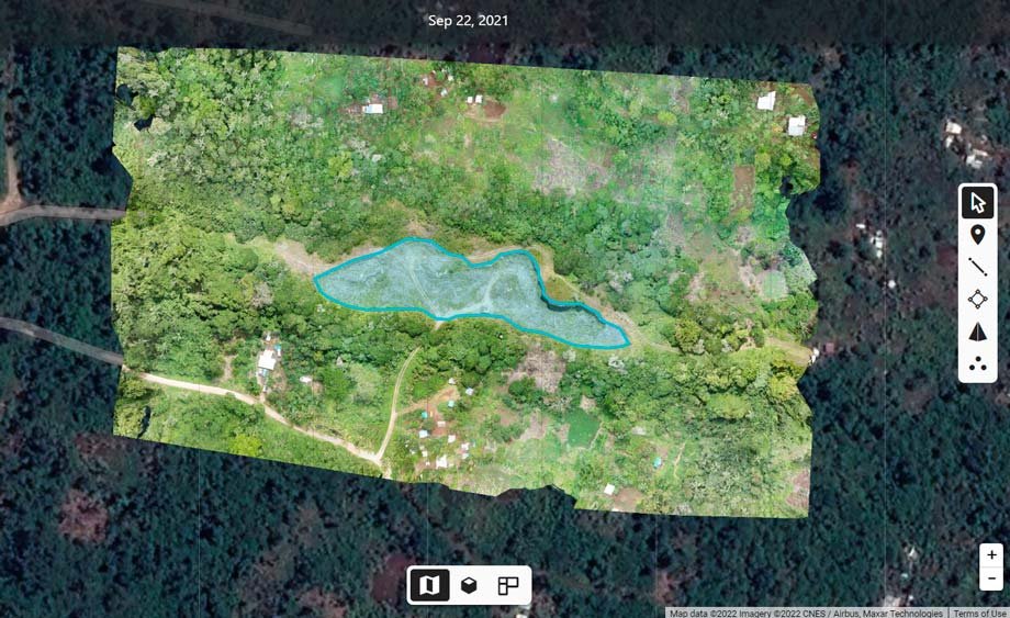
Volume Calculations for Quarry
Measure By Drone can provide an accurate calculation of the cubic area of a quarry before and after further mining, that is time stamped to allow correct determination of how much excavation has taken place. This can provide a low cost solution with cloud based records of your quarry if you are the customary land owner, Government or Licensee.
Our Affiliations

About Us
We believe utilising technology in removing these barriers and historical problems.
Traditional surveying is hard. Vanuatu is a tropical jungle with 83 islands. We do not blame traditional surveying costs for being high. It is hard to survey in thick jungle and in remote areas.
Drones are highly accurate and not subjective to the errors. Large areas can be surveyed to high levels of accuracy. At 2.8 cm over 5 km we think is very accurate.
Mapping and surveying completed at a fraction of the cost of traditional surveying. We are making the playing field more level, including empowering Custom Land Owners. Mapping and surveying for large land areas is now more obtainable.
Case Study
Land without a lease can not be sold, or mortgaged. To create a lease requires a survey. These costs are traditionally done by the investor. It is a long process and expensive, > VUV 100,000 per hectare to survey land is the cost. All of the costs required to place the land into the lease, to now allow the ownership interest to be registered, is money not received by the customary land owner. High costs and challenges to place the land into a lease, the control remains with the investor. Reduce the costs in surveying, reduce the lease creation costs and allow more vatu for the Customary Land Owners. That sounds better to us.
Problem 2:
The land has been surveyed and the survey needs to be amended. It is very expensive to send those traditional surveyors back out into the tropical jungle and change that survey. When it is expensive, those changes will not occur. So either party are disappointed in the outcome. A survey that is not wanted. Sending a drone to re-survey can be done countless times until all parties are happy. Matched with the PropTech of Land Logic and expert Valuers, valuation models can be run instantly to determine the land values to match the site maps created. Amend the map to include more coastline, and see how this applies to the value of the mapped property. Amend the map again, and Land Logic can show again how this changes the land values. PropTech at its best, providing what was not previously obtainable, now obtainable.
Problem 3:
Land surveys from the New Hebrides era. We respect the pioneers and the surveying that was achieved. Vanuatu has now had its independence for over 40 years. Should we still be using these surveys from the pre-Independence era that did not respect customary land boundaries? New leases and customary land claims are still being based on this non Vanuatu time period. Measure by Drone can allow mapping of land to suit Customary Land Boundaries. The land boundaries are understood by Custom Land Owners by walking the land. Ground markers can be identified from the drones and applied into map boundaries. Maps can be confirmed again on the ground and adjusted. PropTech at its best, providing what was not previously obtainable, now obtainable.
Become a Pilot
Contact Us
Let’s Talk
Contact us today to arrange a no cost meeting to see how we can assist you.